
Page County tornadoes sign of stronger storms across the region
By Dylan Cooper, Outdoor columnist
It’s only been three months since I was complaining in my last column about the lingering drought that has stuck around for the better part of three years in Page County and surrounding areas. Don’t let your guard down yet, we are still currently holding at D1/Moderate Drought levels. Local groundwater wells are still in the 5th-10th percentile.
But in the last 90 days we have received 2.3 inches more than the average amount for the time period. The El Nino pattern that was predicted at the end of my last column is here and strengthening, likely attributing to the pattern that is bringing us several storms per week now. The day I wrote this current column it rained four times for just under an inch in total. What a relief to end summer this way!
The local rivers were so low for much of this summer that guides and canoe companies were altering their float plans and potentially even losing some business. On my one personal float, I tore open two holes in a canoe that has never leaked before. In the gardens and fields, spring planting was indeed tough with so many fingers crossed hoping for just enough rain in the nick of time. Those who were a little bit late to plant probably faired well as the dry weather seemed to break all of a sudden with some severe storms starting in June. And severe they were indeed.
On June 11th, it was 99.9 degrees on my personal weather station. It technically wasn’t even summer yet and everything was baking. The yard was on the verge of burning up and mowings were stretching close to two weeks apart. My garden was requiring regular waterings even though I use a geotextile soil covering and either mulch or grass clippings to slow down evaporation and retain water in the soil longer. Then that evening we had a severe T-storm blow through that set the all-time high wind speed for my weather station of 49 mph. My damage was minimal with just some large limbs and garden plants knocked down. The pressure differential hit with such force it sucked my attic access door upwards. But it seemed like after that blitzkrieg, the rains came more consistently each week to where I haven’t watered the garden now since July 3rd.
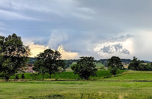
On June 22nd, the folks around Stonyman and Leaksville experienced what was first deemed a tornado and later reclassified as microburst with winds up to 85 mph. The metal roofs from several chicken houses were strewn across the landscape like bits of paper. A few residential houses, barns, powerpoles, and tons of trees suffered quite a bit of damage. One family’s home was even a total loss for which they started a GoFundMe. The National Weather Service said the path of this microburst was 6.7 miles long and 500 yards wide. I had a great view of it from my porch, just north of Luray. It sure looked like a funnel cloud to me at first but with how “ragged” it was, I was assured after those reports that it was just a scud cloud I saw. The wind hardly blew at all at my house during that particular storm. We got lucky.
But not as lucky as my family was on May 30, 2025, when an EF0 tornado “gusted out” at our doorstep. That was the term used by the NWS meteorologist, Chris Strong, whom I spoke with afterwards.
So before this big one hit, I was initially outside watching it approach and, although the scud cloud wasn’t rotating, I did see the layers of clouds behind it moving in opposite directions like there was some rotation or possibly that the northeastern side of the front was slowing down and the southwestern side of the front was speeding up around it. There was hardly any breeze right up until the storm hit. I went inside a minute before it hit.
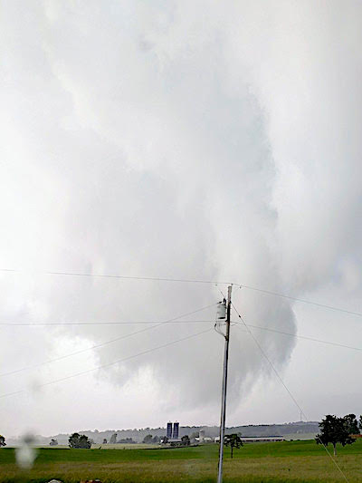
When the high wind and a white wall of water hit the house, it blew water in through every window and door crack. The window in front of me flexed in and out like there was a huge pressure change. I watched heavy porch furniture go tumbling in the NorthEast to North-NorthEast direction. We had a childrens water table get picked up and carried to the other side of the next field, so about 200 yards. The small metal barn that sat a few hundred yards in front of my house got destroyed. It lost the whole roof and had almost entirely collapsed. All of the sheet metal pieces went flying through the hayfield and landed up to 350 yards away from the barn’s original location, all in that same NE-NNE direction. The hay was also pushed down in that direction.
I had some minor damage to the northwest corner of my house where it blew off some soffit and fascia and carried it 20 yds, and broke an aluminum flagpole at its base. Also on that side, several porch things blew in the ENE direction but somehow everything on the southeast porch was untouched. To the south of my house was a large cherry tree on the fenceline that broke and fell right in line with the fence in a ENE direction. All in all, it was pretty minor and fixable damage.
My Accurite weather station was located to the northeast of my house on a fencepost and it recorded a max gust of 45 mph during the event. I really feel like that reading was much less than what the gust speed really was. The weather station was also potentially in the “wind shadow” of the house the way this thing came through. The official report from NWS stated that by the time the tornado gusted out just below us, we only received the resulting downburst wind to the ENE direction, which was consistent with all of my damage. We were so very lucky and blessed that it wasn’t any worse for us.
We certainly aren’t immune to these types of storms, but it seems they are coming with more intensity and frequency. Because again on July 21 this summer, even more tornadoes broke out, stringing a path of destruction from Seneca Rocks, WV to Criders, New Market, and even right here at Thornton Gap. So these actual tornadoes were right on the fringes of Page County. That was the biggest local mini-outbreak since April 2011. Think back to the Derecho in 2012. And then the other two Page County tornadoes on record happened in Stanley in 2009 and 1993. We have seen our fair share of these destructive storms in the last couple decades.
Dylan Cooper is a Page County native and graduate of Luray High School and Virginia Tech. He is a stream restoration specialist and a registered professional engineer in the State of Virginia. An avid outdoorsman and ardent environmentalist, he currently resides in Luray with his family.
Email: currentsolutionsva@gmail.com
•••
PREVIOUS “Nature Notebook” Columns
Nature Notebook ~ What is happening to our water?
Nature Notebook ~ Water we gonna do now? Part II
Nature Notebook ~ How to get scammed by a Waterfowl Guide
Nature Notebook ~ Water we gonna do now? Part I
Nature Notebook: Rallying for the rivers
Nature Notebook: Take a kid outdoors
Nature Notebook: The wild ride of 2022 is over
Nature Notebook: Oh deer! We’ve got a problem to bear
Nature Notebook: How to fish like a tourist
Nature Notebook: My EV experience
Nature Notebook: Falling Feathers at Fulfillment Farms
Nature Notebook: Early seasons slip-ups and successes
Nature Notebook: The Tommy Harris Buck
Nature Notebook: The summer smallmouth smorgasboard
Nature Notebook: Fishing the Cicada Invasion
Nature Notebook: The Next Generation
Nature Notebook: Near-record deer season in Page Co.; upcoming kids’ opportunities
Nature Notebook: Climate Report – One for the Ice Ages
Nature Notebook: Climate Report – A Look at 2020 Data

Be the first to comment