


‘Thunderstorm Wind Event’ measured 500 feet wide, 6.7 miles long
~ PVN staff report
LURAY, June 26 — On Friday, the National Weather Service issued a “Damage Survey” for the Thunderstorm Wind Event recorded on Monday, June 22. While there were no injuries or fatalities related to the afternoon storm, damage was reported at several locations in the central Page Valley.
The NWS report stated that the “wind event” — likely a straight line wind microburst — started at 3:47 p.m. in the central portion of Page County and traveled 6.7 miles east before ending one mile southeast of Stony Man at 3:51 p.m.. Winds reached up to 85 mph and the “event” had a width of up to 500 yards.
While the NWS did not categorize the “event” as a tornado, a photo submitted by a reader makes it appear as something pretty close to a tornado. However, PVN has not confirmed that the photo below was in fact taken on June 22 in the Page Valley. Samuel Clawson submitted the photo on PVN’s social media page, but has not responded to requests for verification. PVN put out a call for photos of damage from the storm just minutes after the high winds subsided at 4:13 p.m.
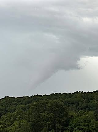
Above, Photo — UNEDITED — as submitted by Samuel Clawson.
Below, same Photo with the Contrast cranked all the way up to highlight the formation.

Immediately following last Monday’s storm about 500 homes were without power. Multiple trees were reported down on U.S. 340 Business south of Luray and throughout the area of the county between Luray and Stanley that has been the victim of multiple high wind events over the years — known locally as Page County’s own “tornado alley.”
The NWS survey summary issued on Friday stated to following:
“A severe thunderstorm on the afternoon of Monday, June 22 produced a downburst of damaging wind that created a path of damage nearly seven miles long through central Page County, Virginia, about two miles south of Luray,” the NWS summary states. “Along that path that passed through the towns of Leaksville and Stony Man, there were many downed trees snapped and uprooted. In addition outbuilding, shed, siding and shingle damage was evident.”
“Peak winds of 85 mph were estimated around Mill Creek Road, Rodeo Drive and Mt. Zion Road between East Brach Road and Redman Store Road where there was substantial structural damage,” the report summary continues.
“A home roof was partially lifted on Rodeo Drive. There was also roof damage to two homes on Mt. Zion Drive, where about half of the windward side of each roof was lifted off. The same was true for chicken houses on the property, where substantial portions of the tin roofs were lifted off and thrown downwind, or bent. Large hay bales were rolled tens of yards. Damage was noted to be unidirectional with storm movement, generally thrown to east.”
For more from the National Weather Service, visit https://www.weather.gov/
•••
RELATED ARTICLES

Be the first to comment