


Tornadoes hit West Virginia and counties of Frederick, Shenandoah, Rockingham, Page, Rappahannock and Shenandoah National Park
By Randy Arrington
LURAY, July 29 — A little over a week ago, a “supercell thunderstorm” washed across the region and wreaked havoc from Pendleton County, W.Va. to the Shenandoah National Park. According to a report released by the National Weather Service on Wednesday, that storm system produced high winds resulting in the formation of five separate tornadoes that touched down in the valleys.
“A complex of supercell thunderstorms developed over the upper Ohio River Valley during the afternoon of Tuesday, July 21st, 2026. These thunderstorms tracked east over the Appalachian Mountains and produced five tornadoes over the mountainous region of eastern West Virginia into northwestern Virginia,” states a July 29 NWS report. “Two tornadoes touched down in Pendleton County, West Virginia, the first observed tornadoes in the county since 1998 and only the third and fourth tornadoes on record since 1950.”
Two of the five tornadoes touched down on the west and east sides of Luray near New Market and Panorama at Shenandoah National Park. Following three tornadoes recorded in West Virginia between 6:20 p.m. and 7:45 p.m., a tornado was recorded touching down about 8:08 p.m. near Timberville. That twister generated peak winds of 85 mph. It traveled 7.7 miles along the ground at a width of 100 yards and ended 10 minutes later about 1.9 miles northwest of New Market, according to NWS.
The NWS July 29 report states: “A tornado touched down on a farm in the 19300 block of Mechanicsville Road. Numerous trees on this property had their tops snapped off, with farm equipment (trailers and carts) tossed about. In the woods surrounding the property, a path of trees were snapped and uprooted in a convergent pattern. About 50 to 60 percent of the trees in the path were blown over. The tornado tracked through unpopulated woods and fields for about a mile before reaching another farm in the 19600 block of Cold Spring Road. Here, additional trees were uprooted or snapped at the top.”
The closest of the five tornadoes recorded — and the only one to touch down in Page County — hit ground about 8:45 p.m. just east of Panorama. It was the weakest of the five tornados, with peak winds reaching 80 mph. It only lasted two minutes and traveled 2.3 miles into Rappahannock County at a width of 75 yards. (See path below)
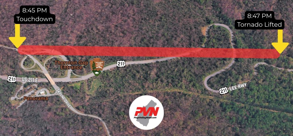
The NWS July 29 report states: “A tornado briefly touched down as a supercell thunderstorm crossed the Thornton Gap entrance to Shenandoah National Park near the intersection of Skyline Drive and US-211 Lee Highway. Numerous trees and large branches were snapped in a convergent manner from near the top of the ridgeline to a couple miles on the lee side of the ridge. Several metal signs were blown over at the Thornton Gap entrance. The tornado dissipated in the woods prior to reaching Sperryville. KLWX radar indicated rotation co-located with a tornadic debris signature as the storm crossed this location.”
The tornadoes that were recorded in the region on July 21 grew progressively weaker as the storm traveled east. The first tornado recorded in Hampshire County, W.Va. hit ground near High View at 6:20 p.m. with peak wind gusts of 110 mph. That initial tornado had a width of 225 yards and traveled 3.5 miles along the ground for 10 minutes before lifting at Wild Acres in Frederick County, Va.
The NWS July 29 report states: “A tornado descended on the 5100 block of Back Creek Road. Here there was roof and siding damage to the house and outbuildings. On this farm property and to the east through unpopulated forest, thousands of trees were downed (80 to 90 percent at one point just east of property), many of which were hardwoods 1-2 feet thick snapped at the trunk. Once the tornado crossed the ridge into Virginia, notable tree damage occurred across the northernmost part of Wilde Acres, VA. Damage was first visible on Otter Trail and extended southeast with damage visible on each street until stopping near Fawn Drive. While tree damage was visible throughout this path, the greatest concentration of damage was on Cardinal Drive. Trees were observed uprooted, snapped, or sheared off at the top. Considerable leaf and small branch debris was observed throughout the entire path.”
The third tornado traveled a total of 12.9 miles along the ground at a width of 150 yards with winds peaking at 100 mph. It hit ground at 7:25 p.m. near Kiser Gap, W.Va. and lasted 20 minutes before lifting at Crider, Va.
The NWS July 29 report states: “Scattered to numerous large trees uprooted and snapped along the path that started along Kiser Gap Road a half mile north of the intersection with US Route 33. The tornado tracked east-northeast. Where it crossed the 1600 block of Troublesome Valley Road it snapped a tree down over the road on a vehicle. The driver was extracted uninjured. Substantial tree damage continued over the 1000 to 2300 blocks of Corner Road, and 6500 to 7000 blocks of Sweedlin Valley Road and the 300 block of Redbud Hill Lane. The tornado then tracked through an unpopulated, wooded area across the ridge/state line. It reached the 24300 block of Gochenour Lane 3 miles southwest of Criders. The damage continued up Gobble Mountain before lifting. In summary, thousands of trees were downed along this rural 10.5 mile path. In peak intensity areas, most of the trees in the path were uprooted or snapped. Structural damage was mainly from tree falls, although there was some wind damage to siding and outbuildings noted.”
The second tornado on July 21, recorded at Seneca Rocks, W.Va., was the weakest of the five, only traveling two-tenths of a mile and lasting only two minutes. Its peak winds reached 80 mph with a width of 75 yards. It touched down at 7:04 p.m.
The NWS July 29 report states: “A tornado briefly touched down near Seneca Rocks just after 7 PM. Damage was limited almost entirely to trees. About 30 to 50 percent of trees were damaged on property in the 400 block of Thunder Road, with trees mostly uprooted in a convergent pattern. The tornado tracked east-northeast. None of the farm buildings sustained significant damage, nor did the house on the property. The tornado crossed the road and tracked up a hillside across the street with continued tree damage before dissipating after about two minutes.”
According to the Enhanced Fujita Scale, three of the five tornadoes were an EF-0, which includes twisters with winds of 65 to 85 mph. The first and third tornadoes recorded on July 21 were graded as EF-1, which includes winds ranging from 86 to 110 mph. An EF-5 tornado — the highest — includes twisters with winds of more than 200 mph.
No injuries and no dollar amount on damage from the July 21 tornadoes has been reported.
On June 22, the Page Valley experienced what NWS called a “wind event” — likely a straight line wind microburst — which started at 3:47 p.m. in the central portion of Page County and traveled 6.7 miles east before ending one mile southeast of Stony Man at 3:51 p.m.. Winds reached up to 85 mph and the “event” had a width of up to 500 yards. It was never officially labeled a tornado. Immediately following that storm about 500 homes were without power. Multiple trees were reported down on U.S. 340 Business south of Luray and throughout the area of the county between Luray and Stanley.
The NWS Damage Survey for the “Thunderstorm Wind Event” issued on June 26 reads: “A severe thunderstorm on the afternoon of Monday, June 22 produced a downburst of damaging wind that created a path of damage nearly seven miles long through central Page County, Virginia, about two miles south of Luray. Along that path that passed through the towns of Leaksville and Stony Man, there were many downed trees snapped and uprooted. In addition outbuilding, shed, siding and shingle damage was evident.”
There were no reported injuries from the June 22 event.
“Peak winds of 85 mph were estimated around Mill Creek Road, Rodeo Drive and Mt. Zion Road between East Brach Road and Redman Store Road where there was substantial structural damage,” the June 26 report continues. “A home roof was partially lifted on Rodeo Drive. There was also roof damage to two homes on Mt. Zion Drive, where about half of the windward side of each roof was lifted off. The same was true for chicken houses on the property, where substantial portions of the tin roofs were lifted off and thrown downwind, or bent. Large hay bales were rolled tens of yards. Damage was noted to be unidirectional with storm movement, generally thrown to east.”
Here’s the July 29 report from the National Weather Service on all five confirmed tornadoes: https://partnerservices.nws.noaa.gov/products/cache/210-2026/PNSLWX/6cb20db89ba807264bc0b9d594e3995f
•••
RELATED ARTICLES

Be the first to comment