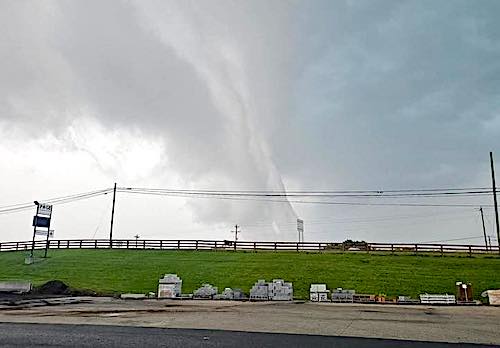
First tornado in Page County since 2009; first in Luray since modern records
By Randy Arrington
LURAY, May 30 — It wasn’t a “straight line wind” or a “microburst.” On Saturday afternoon, the National Weather Service confirmed that Friday’s violent storm over the area produced rotations that formed an EF-0 tornado that touched down just north of Luray in the Kimball area.
“The tornado was on the ground for about two minutes,” the May 31 report stated.

NWS issued a Tornado Warning at 5:50 pm on Friday as Doppler radar indicated rotation near Mount Jackson was headed east at 40 mph. Phones buzzed to alert the 20,000 people in the warned area to seek shelter.

Fifteen minutes later, a tornado touched down near the Luray Mobile Homes community where “numerous large trees and branches snapped and uprooted with some falling on cars and trailers along Luray Mobile Homes Lane.”

The official time stated for the weather event was 6:06 p.m. on Friday. Winds reached 75 mph. The tornado’s path was 50 yards wide, and it traveled 1.1 miles on the ground. While some damage and downed trees were reported, the Page County Sheriff’s Office stated late Friday evening there were no injuries.
“This was a significant event in a very short period of time. While some properties were damaged, we are thankful to report that no serious injuries have been reported,” the sheriff’s online statement reads. “I’d like to take a moment to thank our deputies who did an outstanding job earlier this evening, helping to clear roads and ensure Fire & Rescue had access in case of emergency — even before VDOT crews could get in for cleanup. Their quick action made a real difference during a fast-moving situation.”
“Our Emergency Communications Center (ECC) also deserves major recognition,” the statement continues. “They were hit with a very high volume of calls and had to go to a Level 2 status. Even under pressure, they kept things running smoothly and ensured help got where it was needed.”
Additional tornado damage occurred near Kimball Road, Springfield Road, and Outpost Road where trees and fences were downed, and a small barn/shed was destroyed, according to the National Weather Service’s preliminary storm survey.
A Tornado Watch was issued for the region at 1:35 pm, indicating conditions were favorable for the development of tornadoes. Storms approached the Page Valley in the late afternoon. A Severe Thunderstorm Warning was issued at 5:27 pm.

The Tornado Warning expired at 6:30 pm as the storm moved east into Rappahannock County. The Tornado Warning for the Page Valley was the first of 16 Tornado Warnings the National Weather Service in Sterling would issue on May 30.
Elsewhere in Page County, quarter-sized hail was reported in Marksville and trees and power lines were reported down throughout the county, although unrelated to the tornado.
Friday’s tornado marks the first in Page County since an EF-1 tornado touched down in Stanley on June 3, 2009. That tornado touched down on Pond Avenue and stayed on the ground for 1.67 miles and reached 600 yards wide. The tornado lifted near Brady Road, leaving behind a trail of damage totaling $300,000.
An F1 tornado touched down in Stanley on September 27, 1993, according to the NCEI’s Storm Events Database. It damaged four homes and caused an estimated $500,000 in damage.
Damage estimates are not yet available for Friday’s storm, which is believed to be the first tornado in Luray since modern records began in 1950.
Severe thunderstorms can also pack winds over 60 mph over a large area, like the storm that brought down multiple trees at Luray Elementary School in June 2008 or the infamous June 2012 Derecho that left more than 4 million people without power in the Mid Atlantic.
On May 16, 2025, two people in Fairfax County were killed by trees falling on their cars during a severe thunderstorm.
Residents should heed warnings issued by the National Weather Service and take action to protect themselves. Local residents may subscribe to the Code Red Emergency Notification service provided by Page County free of charge.
•••
RELATED ARTICLES


Very sorry for those who had damage. The land affected was supposed to be turned into a 500 acre solar factory. 350,000 solar panels and supports would have been destroyed , with potential devastating effects on water and wells. A lot of people fought this project and we are all lucky it didn’t go through
We get it Cathy. You hate solar. Glad we’re burning more coal and natural gas. And the farmer didn’t get to choose what happens to his own land. You won. Good job!
Yes, we won in protecting the.county wells and water. Solar is great when sited properly—not where it poses risks to much of the county
It was a message from God saying that a solar farm should have been built there. That had there been one in existence, there wouldn’t have been any reason for a small tornado.
Cathy’s argument is dishonest in every way. The National Weather Service says that this tornado had winds of 75mph. “Solar panels are designed to withstand high winds. Most can handle sustained winds up to 140 mph (2,400 Pascals). Some models and installations are designed for even stronger winds, with some being rated to withstand up to 170 mph.”